


US Public Lands
3.767.00 Reviews
App Specs
- Version
- 2026.7.0
- Updated On
- License
- $3.99
- Downloads
- 10,000+
- Developer
- Two Steps Beyond LLC
- Categories
- Travel & Local
- Platform
- Android, iOS
Screenshots
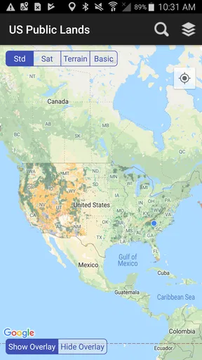
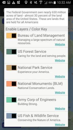
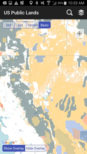
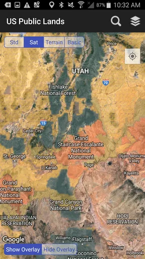
 Analysis by AppCompare
When I’m planning a trip outdoors, the first question is often less glamorous than choosing a trail: where does public land begin, and where does it end? A route can pass through a patchwork of ownership, and a line on a map can change whether I should keep walking, turn around, or check the rules before setting up camp. US Public Lands is built around that practical problem, putting public-land boundary maps on a phone for people exploring the United States.
I see it as a focused tool for the early decisions and in-the-field checks that ordinary travel maps don’t always make easy. It is a paid Travel & Local app from Two Steps Beyond LLC, priced at $3.99, and its current version is 2025.8. The app has a 3.7 average from around 120 ratings and more than 10,000 installs, so it has found an audience, though those figures alone can’t tell you whether its map coverage fits your particular outing. It is rated for Everyone and runs on Android 5.0 or later.
Start with the boundary question
The app makes the most sense when I already have a place in mind but need a clearer picture of the land around it. I might be comparing two possible camping areas, checking whether a road appears to cross public ground, or trying to understand why a promising route seems to pass between different land units. Rather than treating every green patch on a general map as interchangeable, I can use the boundary view to ask a more useful question: what kind of land am I looking at?
That is a narrower job than full trip planning, and I think that distinction matters. A boundary map can help me orient myself, but it should not become my only source for current access, closures, trail conditions, or the rules that apply to a specific site. Public land is not a blanket permission slip. I still need to check the relevant land manager’s current guidance before acting on an assumption, especially when an activity could be restricted or a route approaches private property.
From map check to outing
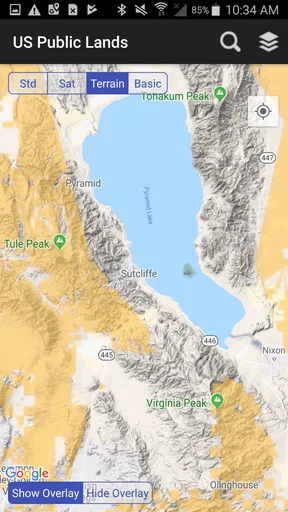
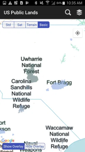
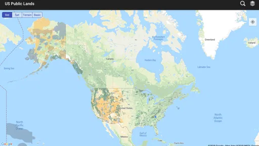
The first time I opened the US Public Lands app, I felt like a kid in a candy store. The interface is clean and intuitive, making it super easy to navigate. Right off the bat, I was greeted with a detailed map that highlights federal public land boundaries across the United States. Whether you're planning a hiking trip or a photography expedition, these maps are your best friends.
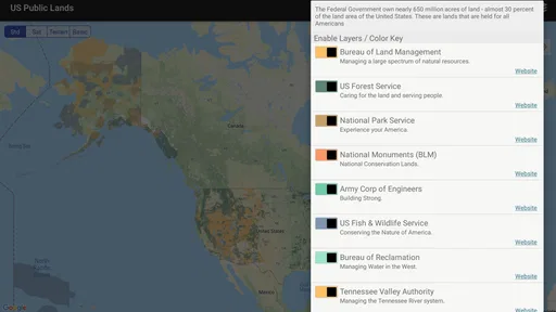
What sets this app apart is its comprehensive nature. It covers a variety of federal lands including National Forests, National Parks, and Wildlife Refuges. I found it incredibly useful for trip planning, especially when I wanted to ensure I was within public land boundaries for camping or hiking.
Build a route with a second check
My practical workflow would start at home, while I still have a reliable connection. I’d locate the area I’m considering, look at the boundary context, and note where a route or access road seems to meet a change in land. Then I’d check the rules with the appropriate land agency and compare the route with a navigation source that is designed for trail directions. These are different jobs: this app helps with the land picture, while a dedicated trail map can be better for turn-by-turn route detail.
Worth Reading Before You Choose

Flipboard Shows What News Apps Must Do Beyond the Feed

Switching to Android Auto Means Rethinking Your Driving Routine

Google Calendar Makes a Crowded Week Easier to Manage

Ludo King Makes the Most of the Minutes Between Plans

Baby Panda World Brings Quick Play to Modern Phones, but Its Game Library Feels Busy

ESPN’s Live Game View Makes Following Close Games Easier
One useful habit is to examine the approach as well as the destination. A campsite or viewpoint may sit on public land while the easiest access crosses a different parcel. Looking at the route’s transitions before leaving can reveal where I need to slow down and verify access, rather than discovering the uncertainty after a long drive or hike. The boundary view is most valuable as a prompt to ask better questions, not as proof that every road or path is open to everyone.
Features That Stand Out
One of my favorite features has to be the offline map capability. I mean, who hasn’t been in the middle of nowhere with a phone that suddenly decides it doesn’t want to connect to the internet? With offline maps, you can download your area of interest before heading out and have access to it anytime, anywhere. It's like having a trusty old paper map that fits in your pocket.
That offline option changes how I’d prepare: I would save the area I expect to visit before driving out, then open it once more while I still have a connection to make sure I have the right map region. If the outing could branch in several directions, I’d think about the surrounding area too, rather than saving only the exact destination. Offline access helps with the map when service drops, but it does not remove the need to bring a charged phone, keep a paper backup for serious travel, or plan for navigation if the device fails.
Another nifty feature is the GPS location service. As someone who tends to wander off the beaten path, having real-time tracking of my location on the map provides peace of mind. Plus, it’s perfect for sharing your location with friends and family if they want to join in on the adventure or simply keep tabs on your safety.
In use, I’d treat the location marker as a useful orientation aid rather than a guarantee that I’m standing exactly where the boundary line appears. Map scale, device positioning, and the conditions around me all affect how confidently I can interpret a close call. If the distinction matters—say, when deciding whether to cross a boundary—I’d pause, zoom out for context, and check authoritative local information instead of relying on a tiny visual gap.
Making the handoff to the real world
For a realistic day out, imagine I’m driving toward a forest for a short hike and want a quiet place to stop for lunch. Before leaving, I’d use the app to see how the surrounding public-land areas fit together, save the map for offline use, and identify places where the approach might cross a boundary. I’d then check access and activity rules with the relevant agency, tell someone my broad plan, and carry the essentials I would take even without a phone.
At the trailhead, the GPS view can help me relate my position to the mapped land. If I reach an unexpected gate, a confusing junction, or a boundary that does not match what I thought I saw at home, I would not treat the app as authority to push onward. I’d stop, reassess, and use signs or current agency information to guide the decision. This is where the app’s role is clearest: it supports a better-informed handoff from planning to on-site judgment, but it cannot make that judgment for me.
An Adventure Planner’s Dream
Planning a trip with the US Public Lands app is a breeze. The app provides detailed information about each land unit, including permitted activities, restrictions, and even historical tidbits. I found this particularly useful for planning my itinerary, ensuring I was well-prepared and informed about the places I visited.
- Permitted Activities: Whether it's hiking, biking, or fishing, the app lets you know what's allowed and where.
- Regulations: Stay informed about rules and guidelines to ensure a safe and enjoyable experience.
- Points of Interest: Discover hidden gems and popular spots to make the most of your trip.
For me, the strongest planning use is not building an entire itinerary inside one screen; it is narrowing down candidate areas and spotting questions to resolve before committing. If I’m choosing between a familiar trail and a less obvious public-land destination, the map context can help me see whether the second option deserves more research. I would still use a trail-focused app or a paper map for route detail and consult the responsible agency for rules that may change by place or season.
This also makes the app useful for people whose outdoor plans are not ambitious hikes. A photographer looking for a legal place to stop, a family choosing a picnic area, or a driver exploring scenic back roads may all benefit from knowing how land boundaries fit around a destination. The trade-off is that boundary knowledge does not automatically provide the practical details each outing needs: road condition, facilities, weather, or whether a particular site is accessible that day.
Where it fits—and where it doesn’t
Compared with a general navigation app, US Public Lands has a more specific purpose: making public-land boundaries the point of reference. Mainstream maps are convenient for finding businesses, roads, and familiar destinations, while dedicated outdoor navigation tools may put more emphasis on trails, elevation, or route recording. I would not expect one of those alternatives to answer every land-ownership question as directly, and I would not expect this app to replace their strengths.
It is a good fit if you regularly travel around federal lands and want boundary context available on your phone, particularly when you prepare in advance for weak service. It is less compelling if you only need directions to a popular visitor site, rarely make outdoor trips, or expect a single app to handle navigation, current regulations, emergency planning, and property boundaries all at once. The $3.99 purchase makes most sense to me when that boundary-focused use will recur, rather than for a one-off trip where a land agency’s own resources may answer the question.
There is also a useful distinction between “public” and “open for my planned activity.” A mapped public unit can have restrictions, access conditions, or areas that call for extra care. I would use the app to identify what deserves checking, then confirm the details before fishing, biking, camping, or taking a vehicle onto a route. That extra step may feel less convenient than trusting one screen, but it is a sensible trade for avoiding an unnecessary detour or a rules mistake.
How it holds up on the trip
Once I’m on the way, offline access and the location display are the features I’d rely on most. I’d open the saved map before service disappears, keep the phone available without draining it unnecessarily, and check my position at decision points rather than staring at the screen while walking. This is a small workflow change, but it makes a boundary tool more useful: look ahead at home, use it sparingly outdoors, and stop to verify when the map and the terrain leave room for doubt.
The main friction is that a map can look reassuringly precise even when the decision is not simple. A line on a screen cannot tell me by itself whether a gate is locked for a temporary reason, whether a route is maintained, or whether an activity has a local restriction. Nor should I assume that a displayed point of interest is a substitute for current directions. Keeping those limits in mind prevents the app from being used for a job it was not designed to do.
There is a small learning curve in deciding what to do with the information. New users may open a boundary map expecting a ready-made route and instead need to combine it with agency rules and navigation. I see that as manageable, but it is worth knowing before buying: this is most rewarding for someone who enjoys planning and is comfortable checking more than one source, not someone who wants a hands-off itinerary.
Why You’ll Love It
If you’re an outdoor enthusiast like me, you’ll appreciate that the app is constantly updated. It's reassuring to know that the information provided is current and reliable. Plus, the app’s developers are responsive to feedback, which means they’re always working on making it better. It’s like having a personal guidebook that evolves with technology and user needs.
Another aspect I adore is the community feel. The app encourages users to submit reviews and share experiences, creating a platform where fellow adventurers can exchange tips and stories. It's like having a mini community of explorers right in your pocket.
Even with community input, I would separate personal reports from official rules. A visitor’s note can be a helpful clue about what to investigate, but conditions and access can change, and another person’s experience may not match my own trip. For me, the best sequence is to use shared experiences for ideas, the map for spatial context, and the land manager for decisions that depend on current policy.
That combination makes the app more useful for repeat visitors than for someone hoping to be told exactly what to do. If I return to a region, I can begin with a clearer sense of how its public lands are arranged and spend my research time on the specific access and activity questions that matter to that outing. The map is a starting point for informed choices, not a replacement for local knowledge.
The Final Verdict
Would I recommend the US Public Lands app? Absolutely. It's a one-stop-shop for anyone looking to explore the vast expanses of America’s public lands. Whether you're a seasoned hiker or just someone who loves to escape into nature every once in a while, this app is your perfect companion. It's user-friendly, packed with useful features, and constantly evolving to meet the needs of its users.
My recommendation comes with a clear condition: use it as a boundary reference within a broader plan, not as your only authority outdoors. Its offline maps and GPS location can make a real difference when signal is unreliable, while checking agency guidance and carrying sensible backups keeps that convenience in perspective. For regular explorers who want public-land context close at hand, that is a useful balance.
So, if you're ready to embark on your next adventure, give the US Public Lands app a try. It might just become your new favorite travel buddy.
Pros
- Extensive coverage of public lands.
- User-friendly interface and easy navigation.
- Regular updates with new information.
- Offline access to maps and data.
- Detailed information on land usage.
Cons
- Limited international coverage.
- Requires in-app purchases for full access.
- Occasional GPS inaccuracies.
- Interface can feel cluttered at times.
- Some data may be outdated.
FAQs for US Public Lands
What is the primary purpose of the US Public Lands app?
The US Public Lands app is designed to help users identify and navigate public lands across the United States. It provides detailed maps and information about different types of public lands, such as national parks, forests, and wildlife refuges, making it an essential tool for outdoor enthusiasts and travelers.
How accurate and up-to-date is the information in the app?
The app offers reliable and regularly updated data sourced from official public land management agencies. It uses current geographic information system (GIS) data to ensure accuracy. Users can trust the app for planning their trips, although it's always wise to verify any specific regulations or changes directly with local authorities.
Is the US Public Lands app available offline?
Yes, one of the app's key features is its offline functionality. Users can download maps and data to their devices, allowing them to access information without a cellular or Wi-Fi connection. This is particularly useful in remote areas where internet access may be limited or unavailable.
What platforms is the US Public Lands app available on?
The US Public Lands app is available for both Android and iOS devices. Users can download it from Google Play Store or Apple App Store. It is designed to work seamlessly across different devices, ensuring a user-friendly experience regardless of the platform.
Does the app provide information on permitted activities and regulations?
Yes, the app includes details on permitted activities within various public lands. Users can access information about hiking, camping, fishing, and off-road activities, along with any specific regulations or restrictions. This helps users plan their activities in compliance with local rules and guidelines.


